Магазин работает в обычном режиме. Доставка с нашего склада в США занимает около 6 недель. Оплата рублями и любой валютой. Предлагаем поставки магазинам и импортерам по оптовым ценам
Подробнее об оплате и доставке
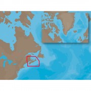
Navionics Platinum+ 912PP - US West Coast - Hawaii - CF Card
Бонусные баллы: 4

43204.00 Р
Platinum+ - US West Coast and Hawaii - CF Format
Covers: US WEST COAST-HAWAII - PUGET SOUND, WASHINGTON, OREGON, CALIFORNIA, BAJA, HAWAII From Vancouver, BC to Cabo San Lucas, MX, Cape Flattery and offshore bathymetric data and the entire chain of the Hawaiin Islands. Includes the Columbia River from the entrance to Lake Wallula/Snake River entrance.
Multi-dimensional marine charts include comprehensive Nautical Chart, incredible fishing detail with SonarChart™ 1 ft HD bathymetry map, and Community Edits. Plus, exclusive Platinum features take the boating experience to a whole new level: 3D view, high-resolution photo/chart overlay, port photos, and geo-referenced coast pilots. Register online for one year of daily updates to Nautical Chart, SonarChart and Community Edits.
Visit Navionics.com/downloads-updates to enjoy preloaded content and download the latest charts.
Enhance SonarChart™ with sonar logs you collect using a plotter or mobile device.
High-definition fishing detail, 3D View, Satellite overlay, port photos, tides & currents, safety depth contours, navaids, coastal points of interest, and port services information.
Check compatibility at Navionics.com, which is continuously update.
Covers: US WEST COAST-HAWAII - PUGET SOUND, WASHINGTON, OREGON, CALIFORNIA, BAJA, HAWAII From Vancouver, BC to Cabo San Lucas, MX, Cape Flattery and offshore bathymetric data and the entire chain of the Hawaiin Islands. Includes the Columbia River from the entrance to Lake Wallula/Snake River entrance.
Multi-dimensional marine charts include comprehensive Nautical Chart, incredible fishing detail with SonarChart™ 1 ft HD bathymetry map, and Community Edits. Plus, exclusive Platinum features take the boating experience to a whole new level: 3D view, high-resolution photo/chart overlay, port photos, and geo-referenced coast pilots. Register online for one year of daily updates to Nautical Chart, SonarChart and Community Edits.
- One Foot Contours Inshore and Nearshore
- 3ft and 6ft Contours Offshore Beyond 90ft
- 3D View
- Satellite Overlay
- Port Photos
- SonarChart
- Tides & Currents
- Safety Depth Contours, Navaids
- Coastal Points-Of-Interest
- Port Services Information
Visit Navionics.com/downloads-updates to enjoy preloaded content and download the latest charts.
Enhance SonarChart™ with sonar logs you collect using a plotter or mobile device.
High-definition fishing detail, 3D View, Satellite overlay, port photos, tides & currents, safety depth contours, navaids, coastal points of interest, and port services information.
Check compatibility at Navionics.com, which is continuously update.

Нет отзывов о данном товаре.
Отзывы с оценкой