Магазин работает в обычном режиме. Доставка с нашего склада в США занимает около 6 недель. Оплата рублями и любой валютой. Предлагаем поставки магазинам и импортерам по оптовым ценам
Подробнее об оплате и доставке
C-MAP MAX NA-M026 - Great Lakes & The Maritimes - C-Card
Бонусные баллы: 2
21122.32 Р
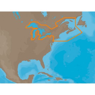
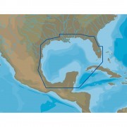
NA-M026 => Great Lakes, Northeast Coast and Approaches
Coverage of the Great Lakes, St. Lawrence River and Northeast United States. Coverage of the Great Lakes also includes Fox River and Lake Winnebago, Lake St. Clair, Rideau Canal, Ottawa River and the Trent-Severn Waterway. Includes all coastal charts for New Brunswick and Nova Scotia in Canada and Maine, New Hampshire, Massachusetts, Connecticut and New York in the U.S. Also included is coverage of the Hudson River and Lake Champlain as well as the Erie Barge Canal.
Coverage of the Great Lakes, St. Lawrence River and Northeast United States. Coverage of the Great Lakes also includes Fox River and Lake Winnebago, Lake St. Clair, Rideau Canal, Ottawa River and the Trent-Severn Waterway. Includes all coastal charts for New Brunswick and Nova Scotia in Canada and Maine, New Hampshire, Massachusetts, Connecticut and New York in the U.S. Also included is coverage of the Hudson River and Lake Champlain as well as the Erie Barge Canal.
Похожие товары
Вы смотрели
Бонусные баллы: 14
Бонусные баллы: 12
Нет отзывов о данном товаре.
Отзывы с оценкой