Магазин работает в обычном режиме. Доставка с нашего склада в США занимает около 6 недель. Оплата рублями и любой валютой. Предлагаем поставки магазинам и импортерам по оптовым ценам
Подробнее об оплате и доставке
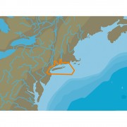
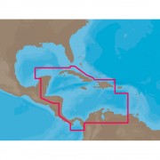
C-MAP 4D NA-D022 - USA East Coast & Bahamas - Full Content
Заканчивается
Бонусные баллы: 3

33026.99 Р
NA-D022 - U.S. East Coast and the Bahamas
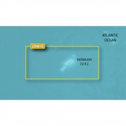
Coverage of the United States Atlantic coast from Passamaquoddy Bay, ME down to Key West, FL, with extended coverage into the Gulf of Mexico over to Perdido Bay, FL. Includes coverage of Bermuda and all of the Bahamas. Also includes coverage of the Hudson River, Lake Champlain, Erie Barge Canal, Savannah River, St John's River and Okeechobee Waterway. Caribbean coverage includes charts from Explorer Chartbooks and Wavey Line Publishing.
Full 4D Content
When you choose Full 4D content you will experience the latest in navigation data and technology such as:
- 3D Chart View - The world has three dimensions.
When you add the 4th dimension of time - meaning consistent, periodic updates - you combine the most detailed 3D height and depth worldwide database with a continuous update process to give you a personalized navigation experience with up-to-date data for safe navigation. - High-Resolution Satellite Imagery - See the real world on your screen.
C-MAP 4D includes a navigational perspective with high-resolution coastal imagery overlaid on the most accurate and up-to-date vector data, plus thousands of extraordinary photos for the most popular marinas and areas of interest. - Digital Raster Charts - Innovate tradition.
With raster charts, you have an additional reference source for navigational awareness. Get "at-a-glance" information using the nautical paper charts overlaid on the multi-dimensional shaded relief to have a new visual experience. - Easy Routing - Automatically create a route.
Enter start and end points along with specific boat parameters and automatically receive waypoints of the shortest route; highlights potential hazards and displays varying levels of alerts for each segment of the route, allows you to manually adjust the route. - Guardian Alarm - An extra layer of safety.
When activated, Guardian Alarm performs an automatic forward-scanning check for obstacles. Use the feature as an added backup to alert you should you head toward a potentially harmful object. - Detailed NavAids
- Route Check
- Detailed Marina Charts
- C-Marina Ports Database
- Multi-Language Capability
- Dynamic Tides & Currents
- Photos & Diagrams
- Depths & Land Elevations
- Perspective View


Нет отзывов о данном товаре.
Отзывы с оценкой