Магазин работает в обычном режиме. Доставка с нашего склада в США занимает около 6 недель. Оплата рублями и любой валютой. Предлагаем поставки магазинам и импортерам по оптовым ценам
Подробнее об оплате и доставке
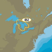
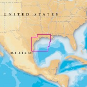
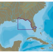
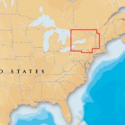
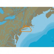
Humminbird LakeMaster Great Lakes - microSD™
Бонусные баллы: 1

13305.81 Р
LakeMaster Great Lakes - microSD™
More Accuracy, More Confidence
For decades LakeMaster has been putting accuracy, detail, and a passion for angling on the map lead by a devoted team of GIS analysts, anglers, and surveyors alike. LakeMaster's partnership with Humminbird is now beginning to break down more barriers than ever before. Humminbird LakeMaster mapping is not only growing in coverage area, but also expanding the possibilities of cartography. Together innovation continues to lead to new and exciting products, seamless integration between software and hardware, a relentless focus on helping anglers catch more fish, and a commitment to doing it all right here in the U.S.A.
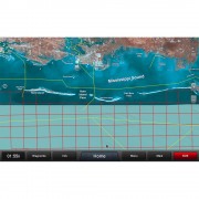
GPS Map Cards
Accuracy and detail give anglers using Humminbird LakeMaster GPS Map Cards the best High Definition hydrographic maps on the market. More coverage means more opportunity for catching fish on your favorite bodies of water.
High Definition vs Standard Definition
High Definition is ascribed to a chart by LakeMaster when the underlying data is of such high quality and density that the resulting map is very accurate. Only the most accurate and detailed surveyed data combined with the talents of our experienced GIS analysts earn the "High Definition" label. Humminbird Lakemaster High Definition lake charts have the highest level of accuracy, especially in the shallow "fishing structure" areas. In some cases, the bathymetric data to build the map has been gathered by LakeMaster's own survey team. These lakes are identified as a "LakeMaster High Definition" chart.
Contour Line Density
Spacing of contour lines does not determine if a map is high definition or not. LakeMaster uses 1-ft contours on most of our high definition maps, but not all. On some lakes that are deep and have steep break lines, 3-ft contour spacing might be used because the lines become so dense at 1-ft that it isn't functional. It's still high definition i.e. "high accuracy".
Features:
More Accuracy, More Confidence
For decades LakeMaster has been putting accuracy, detail, and a passion for angling on the map lead by a devoted team of GIS analysts, anglers, and surveyors alike. LakeMaster's partnership with Humminbird is now beginning to break down more barriers than ever before. Humminbird LakeMaster mapping is not only growing in coverage area, but also expanding the possibilities of cartography. Together innovation continues to lead to new and exciting products, seamless integration between software and hardware, a relentless focus on helping anglers catch more fish, and a commitment to doing it all right here in the U.S.A.
GPS Map Cards
Accuracy and detail give anglers using Humminbird LakeMaster GPS Map Cards the best High Definition hydrographic maps on the market. More coverage means more opportunity for catching fish on your favorite bodies of water.
High Definition vs Standard Definition
High Definition is ascribed to a chart by LakeMaster when the underlying data is of such high quality and density that the resulting map is very accurate. Only the most accurate and detailed surveyed data combined with the talents of our experienced GIS analysts earn the "High Definition" label. Humminbird Lakemaster High Definition lake charts have the highest level of accuracy, especially in the shallow "fishing structure" areas. In some cases, the bathymetric data to build the map has been gathered by LakeMaster's own survey team. These lakes are identified as a "LakeMaster High Definition" chart.
Contour Line Density
Spacing of contour lines does not determine if a map is high definition or not. LakeMaster uses 1-ft contours on most of our high definition maps, but not all. On some lakes that are deep and have steep break lines, 3-ft contour spacing might be used because the lines become so dense at 1-ft that it isn't functional. It's still high definition i.e. "high accuracy".
Features:
- Depth Highlight
- Shallow Water Highlight
- Water Level Offset
- Quick Find Lake List
Похожие товары
Вы смотрели
Заканчивается
Бонусные баллы: 2
Нет отзывов о данном товаре.
Отзывы с оценкой